Urban Planning in 3D: How Creating a Digital Twin Leads to Smarter Cities

Who will you meet?
Cities are innovating, companies are pivoting, and start-ups are growing. Like you, every urban practitioner has a remarkable story of insight and challenge from the past year.
Meet these peers and discuss the future of cities in the new Meeting of the Minds Executive Cohort Program. Replace boring virtual summits with facilitated, online, small-group discussions where you can make real connections with extraordinary, like-minded people.
By now, I’m sure we’re all familiar with the following statistics: according to the UN, by 2050 the world population is expected to rise to almost 10 billion people, with anywhere from 66 percent to 80 percent of those people clustering in urban areas. Meanwhile, the vast majority of those cities were built around expectations, patterns of living and technologies that predate the social and environmental awareness of the 20th century, let alone the concerns and challenges particular to the 21st. Add to this mix the fact that so many of the world’s major cities are located along coastal waterways subject to the ravages of extreme weather and rising sea levels, and the situation facing contemporary urban planners can appear more dire now than at any point in our history.
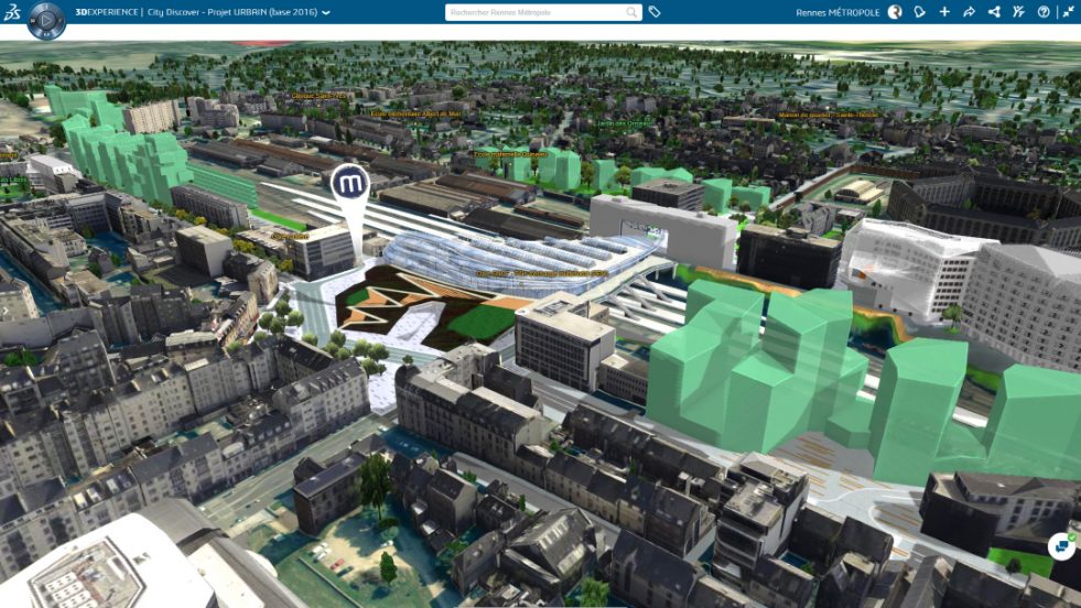
If our present moment presents us with a seemingly insurmountable range of challenges, however, it also offers toolkits for addressing these challenges; technologies that allow us to understand, imagine, visualize and plan the future of cities by addressing the full complexity of contemporary urban life. The city of Rennes, in the Brittany region of France, is one of a growing number of cities seeking to make the best use of 3D visualization techniques to help address the significant challenges it faces.
A vibrant, welcoming city known as much for its heritage and historic sites as for its universities and research laboratories, Rennes has long been a magnet for tourists and new residents alike. The city’s thriving tech sector – Rennes is second only to Paris as a center for French digital services and telecommunications companies – has fueled a consistently robust local job market, with the result that the local population has been rising steadily since 1999, and has been the second-fastest growing metropolitan area in France since 2014.
All of this growth has been of great social and economic benefit, but it has come at a time when those charged with the wellbeing of cities are more aware than ever that we have to build, work, live, and grow more sustainably if we are going to achieve the future we want for ourselves and our families.
In 2014, at the initial stages of the surge of new businesses and residents into the area, the French government united Rennes with 42 other towns and villages in the Ille-et-Vilaine department to create a new conurbation, Rennes Metropole. This new governmental framework was established to enable planners and city managers to better organize the development required to accommodate the growing population by centralizing planning tasks and procedures, providing a framework for coordinating regional strategic goals with local tactical responses, and allowing data to be gathered from a wide range of sources and shared collaboratively with all stakeholders.
Following the establishment of Rennes Metropole, the task facing the city’s urban planners shifted dramatically. Overnight, planning staff had to expand their vision to consider the needs of a population that more than doubled to reach almost 430,000 people, and to coordinate new housing, commercial, and service spaces, transit, and open space over a territory of more than 270 square miles. Further contributing to the scale of the challenges facing the Metropole, regional leaders agreed to an aggressive set of measures intended to reduce per capita energy consumption and promote resilience and sustainability at the same time that they sought to add thousands of residential units, and hundreds of thousands of square feet of commercial space to the region every year.
Recognizing that traditional tools of urban planning and management were no longer sufficient to managing the complexities of regional development across the Metropole, leadership committed to bold new solution. They would commission the creation of a full-fidelity, data rich digital model of the city; a digital twin that would mirror the physical features of the territory and capture its processes in real time to provide leaders and planners, as well as businesses and residents, with a means to come together and understand the city as it is, and work together to shape the city of the future as they want it to be.
Modeling is nothing new to the practice of urban design, any more than the careful collection and tabulation of data is anything new to the practice of civic management. What makes the Virtual Rennes project distinct is the goal of bringing these elements together into the same referential – a single source for all knowledge about the city – where previously, data would be locked into the silos of departments and distributed across a range of often incompatible formats.
The use of a full-fidelity spatial model as the base for a common referential directly addresses the fact it can be difficult for one team to understand the implications of data collected by another (one of the most common difficulties that faces any attempt to bring together a wide range of territorial data for planning and management purposes), and does so in a way that can help identify and build consensus toward the most effective actions to take. The Rennes Metropole planning team uses the 3D virtual twin to envision the potential growth of the region, based on goals and targets set by leadership, optimize the systems and networks necessary to serve that new development, plan new urban services, communicate effectively with the public, and administer construction to minimize delays and negative effects.

Envision
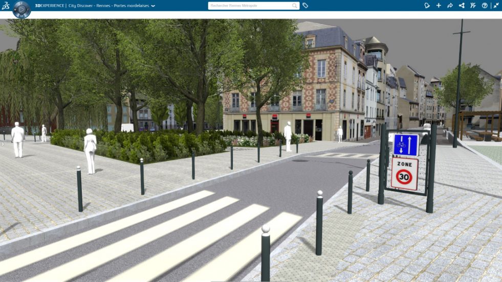
While the Virtual Rennes model offers an immersive quality visualization of the current state of the city, it is most valuable to the management and planning teams of the Metropole as a tool for evaluating the potential effects of future development so that these can be best adapted to the region’s long-term strategic plans and to the expectations and preferences of current residents. City planners run analyses of potential future development based on the policy proposals of political leaders in a model that captures not only the physical and material conditions of the current city, but which serves as a gateway to a host of related data sets. Information about transportation infrastructure, not merely the physical details of streets, bike paths and sidewalks but also performance data about the routes, timing and capacity of bus and light rail, provides crucial detail about the accessibility of new proposals and the potential impact of development on congestion. Layers of environmental data which not only display the contours of local terrain, but also provide graphic visualizations of flood potential due to both natural landforms as well as the effects of paved and landscaped surfaces, enable planners to make informed choices about how to organize new site work to promote safe and resilient development.
Optimize
Bringing together static physical data about city resources with real-time data about the usage of those resources, mapped against a 3D representation of the Metropole’s terrain enables new projects to be located where they can best enhance the experience of the city without the negative social and economic consequences of stressing or overloading public facilities. Visual representations of existing transportation infrastructure linked to graphic analysis of use and capacity – traffic congestion, travel times between vehicle intersections or bus and metro stops, open seats on busses and light rail trains – enables planners to prioritize new development along efficient and underutilized transport lines, while identifying routes where congestion and high service usage makes new development less desirable. Identifying the availability of local resources such as schools, parks, and commercial spaces gives developers a view of amenities that could be attractive to potential tenants and buyers, while having access within the model to real time data about class sizes and wait lists, available recreation programs and the schedules of local sports teams, and public comments and feedback about local shops and restaurants, can help developers to more precisely calibrate their proposals to best suit the local context and the needs of potential residents.
Communicate
Beyond any particular visualization, simulation, or optimization task that could be enabled through the use of a centralized 3D referential, it is the role the digital twin can play in facilitating collaboration and communication across disciplinary boundaries and professional silos that represents the most significant advance of the Virtual Rennes project. Urban planning and civic management have long relied on a process of deciding on new development without input from the larger community, announcing those decisions, and then investing copious staff time trying to defend their decisions, scrambling to incorporate community feedback, and, in some cases, adapt their work to issues and conditions they were unaware of or unprepared for prior to their announcement.

These processes worked well enough for situations where residents felt they had little recourse to having their voices heard and their concerns addressed. The advent of the internet and widespread social media have long since brought those days to an end and ushered in a new era in which city managers generally, and planners, especially, seek to engage the broader community well in advance of potential new development and engage in dialog with them not only to hear their hopes and concerns, but also to invite them into the development process as a source of expertise in their own right. Projects that begin by bringing the community onboard early, and working closely with them throughout the course of development are more likely to be successful. By making the city as a whole a stakeholder in the project, planners and managers encourage the community to become invested in seeing a project realized and to work and contribute actively to bring that about.
In an age where misinformation and misunderstanding are widespread, trust and consensus are ever more difficult to build. One significant benefit of immersive 3D visualization is its immediacy – navigating the digital twin is simple and straightforward, it requires no special training to understand and no advanced knowledge to interpret. Immersive 3D visualization combines representational conventions that are broadly shared, thanks to the ubiquity of animation techniques commonly used by contemporary computer games and movies, with the immediacy of direct visual experience of urban form to make even the most complex ideas and projects readily understandable.
The urban digital twin as a collaborative platform offers city planners, managers, and public leaders with the most potent tool we have yet developed for planning the cities of the future. In the face of almost insurmountable complexity, 3D visualization allows us to see our cities as they are now, and to navigate smoothly across data captured at a wide variety of scales, while positioning us to use that understanding as a springboard for imagining what the future of those cities could be. The digital twin, with its immersive fidelity to the physical world overlaid against a deep pool of data about urban processes, enables coordination across disciplinary and professional boundaries and builds confidence and trust between professionals and the public by bringing everyone together in a common visual language to help all parties understand the functions of the city, explore potential new urban experiences, evaluate the efficacy of proposed solutions, and plan for new the future in a way that enables us to respond to and address questions we didn’t previously know to ask.
Discussion
Leave your comment below, or reply to others.
Please note that this comment section is for thoughtful, on-topic discussions. Admin approval is required for all comments. Your comment may be edited if it contains grammatical errors. Low effort, self-promotional, or impolite comments will be deleted.
2 Comments
Submit a Comment
Read more from MeetingoftheMinds.org
Spotlighting innovations in urban sustainability and connected technology

Middle-Mile Networks: The Middleman of Internet Connectivity
The development of public, open-access middle mile infrastructure can expand internet networks closer to unserved and underserved communities while offering equal opportunity for ISPs to link cost effectively to last mile infrastructure. This strategy would connect more Americans to high-speed internet while also driving down prices by increasing competition among local ISPs.
In addition to potentially helping narrow the digital divide, middle mile infrastructure would also provide backup options for networks if one connection pathway fails, and it would help support regional economic development by connecting businesses.

Wildfire Risk Reduction: Connecting the Dots
One of the most visceral manifestations of the combined problems of urbanization and climate change are the enormous wildfires that engulf areas of the American West. Fire behavior itself is now changing. Over 120 years of well-intentioned fire suppression have created huge reserves of fuel which, when combined with warmer temperatures and drought-dried landscapes, create unstoppable fires that spread with extreme speed, jump fire-breaks, level entire towns, take lives and destroy hundreds of thousands of acres, even in landscapes that are conditioned to employ fire as part of their reproductive cycle.
ARISE-US recently held a very successful symposium, “Wildfire Risk Reduction – Connecting the Dots” for wildfire stakeholders – insurers, US Forest Service, engineers, fire awareness NGOs and others – to discuss the issues and their possible solutions. This article sets out some of the major points to emerge.

Innovating Our Way Out of Crisis
Whether deep freezes in Texas, wildfires in California, hurricanes along the Gulf Coast, or any other calamity, our innovations today will build the reliable, resilient, equitable, and prosperous grid tomorrow. Innovation, in short, combines the dream of what’s possible with the pragmatism of what’s practical. That’s the big-idea, hard-reality approach that helped transform Texas into the world’s energy powerhouse — from oil and gas to zero-emissions wind, sun, and, soon, geothermal.
It’s time to make the production and consumption of energy faster, smarter, cleaner, more resilient, and more efficient. Business leaders, political leaders, the energy sector, and savvy citizens have the power to put investment and practices in place that support a robust energy innovation ecosystem. So, saddle up.


State of TN.
Gave us the right to create a new smart city…based upon agro/education
954 260 2060
Gary Hunt
Gary – I don’t understand your comment. Can you clarify?