Decision Support Tools that Counter Uncertainty and Risk in Urban Settings

Who will you meet?
Cities are innovating, companies are pivoting, and start-ups are growing. Like you, every urban practitioner has a remarkable story of insight and challenge from the past year.
Meet these peers and discuss the future of cities in the new Meeting of the Minds Executive Cohort Program. Replace boring virtual summits with facilitated, online, small-group discussions where you can make real connections with extraordinary, like-minded people.
Urban Planning Today: Perception vs. Reality
When the planning profession was still nascent in the 1950’s, well defined social needs and the desire to improve poor living conditions were the dominant basis for policy and regulation. By the time the 1970’s and 80’s came around the emphasis shifted towards increasingly pluralistic and open ended outcomes.
This thinking emerged from a number of prominent planning theorists that asserted that the act of planning itself was inherently political and so there could be no ideal social condition that could properly define an ideal intervention to a generalized need. This gave rise to the predominance of advocacy planning, which quite like lawyers taking different sides on issues, works by allowing the strongest planning voice representing a particular attitude, approach and response to a perceived or real problem to prevail.
Since the 1990’s “planning advocacy” has matured and become even more democratized through active public participation and involvement. Today, both planning advocacy and public participation form the backbone of most planning efforts.
 Increasingly, computer simulations and models provide the third leg of this platform on which contemporary planning is done. There are of course many nuances to this highly simplified narrative of how we plan, but we know contemporary planning is tedious, certainly in terms of time and money spent. Often, the lowest common denominator or sub-optimal outcomes are all we can collectively agree on.
This tedium is complicated by the predominant disposition that more development somehow translates to more social benefit (i.e. increases in real estate investment and value will assure better schools, open space and other public amenities). Unfortunately this trickle-down approach doesn’t work with every development issue or location as neatly as might be hoped for.
In our fast paced world our big expectations and high hopes demand ever faster fulfillment. So it’s evident we need better planning delivery mechanisms. Rather than completely reinvent the way we do things, I believe smarter use of technologies and tools already at our disposal can help us do so.
The Changed Nature of Data and Information
We all know that for democratic decision making to truly work, we must have an informed and engaged public. Today, we increasingly find we have too much data and information, quite the opposite of the past inadequacies that plagued the hope for intelligent debate and solutions. Today’s data and information challenges are different and arise from inconsistencies, gaps, or “poor” data. This means available data often needs to be interpreted from multiple sources. Further, such data may be inconsistent in quality, inadequate, or of poor, even excessive granularity (resolution). As we know bringing data into compatible and problem adequate levels takes time.
Many of these data quality and sort problems can be better addressed by understanding the context and nature of the problem itself. Doing so reveals that often too much data is a burden, and often the inadequacies can be offset by clever compensations.
Let’s assume these aspects of data can be effectively addressed. This allows us to focus on the urgent need for good decision support tools that are specifically oriented towards helping stakeholders in the planning process (i.e. the public, decision makers and technical experts). These tools need to help us quickly and reliably comprehend increasingly complex environments so that the common impulses that highjack the discussion focus, or allow competing interests to take over, and decision drift can all be minimized. Doing so is absolutely essential to collectively making the difficult trade-offs necessary to move forward. We cannot address risk and uncertainty without having more mature ways to comprehend the environment in which they occur.
Simulation models vs.?
As mentioned earlier most contemporary planning relies on simulations and complex models to project future needs, minimize risk and uncertainty, as well as assess trade-offs. Any good techie or programmer will readily tell you the limitations of a simulation program. Everyone else is usually challenged. This inability to comprehend undermines the basic expectation of the openness in which today’s planning processes are expected to work.
This bears further elaboration. By their very nature computer simulation models are “black box” tools that are not very stakeholder friendly. What I mean is that the average consumer untutored in the inherent limitations of such simulations tends to often blindly accept their algorithm(s), underlying assumptions and finally their outputs.
Our reality is that most citizens are obliged to take several leaps of faith to comprehend the fullest implications and meaning (and indeed, limitations) of any simulation model’s outputs. The experts who develop such models find these technical details easy, but this is not so for most everyone else. Simulations are thus commonly mistaken to be predictions. Such mistakes lead to grossly misguided policies, regulations and financial commitments that cities can ill afford.
I am not making a case against models and simulations which are clearly an essential part of our life. I am however asserting that we need better (i.e. open and comprehensible) tools that support how our increasingly complex environment can be discussed and then acted upon.
Better Decision Support Tools
The need for such tools is something that has been a deliberate and cumulative process over my three decades of practice. Methodologies developed to do so may seem similar, but are quite different depending upon the scale and context of each setting. I have found that when GIS technology is deployed creatively and with deliberate focus; an open and comprehensible basis for involvement by stakeholders of diverse interests and capability is easier.

Further, GIS based methodologies allow planning risk and uncertainty to be offset in many ways. These include helping participants focus on the effective “decision space” within which the problems and appropriate responses to them lie. They help planning institutions stay focused on how their limited staff and resources are best utilized. The benefits extend to efficiency gains in regulation as well.
Such methods were elaborated at a keynote at the 2015 KLIMATGIS conference in Stockholm, Sweden. Additional underlying work to these methods were also shared during subsequent lectures at the Swedish Royal Institute of Technology.
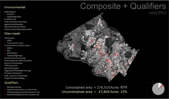
At these venues I spent the most time describing DMAT (Development Management Assessment Tool). This effort was undertaken for the National Capital Parks and Planning Commission (Montgomery County) a Maryland suburb within the Washington Metro area. An abbreviated version of this presentation with this example can be viewed at: https://mix.office.com/watch/1zz0itwn8ldw.
The Trade-offs of better tools for open planning
The fullest benefits of using GIS technology in this way continue to emerge. Here are some that are apparent:
- An open and adaptive process (rather than a black box approach) allows for better trust and comprehension amongst stakeholders having diverse comprehension, skills and perceptions.
- Technology that explains complexity in quick, open and reliable ways prevents varying interests from exaggerating (hidden) agendas and helps keep the original issues in focus. This improves chances for honesty and accountability.
- Tools that help us understand complexity foster better and mature debate on the tough trade-offs that must be made to properly address complex problems and their settings. Simplistic descriptions and stances usually pander to vested interests that tend to manipulate and skew outcomes.
The Democratization of Information and Data
Maturing the open decision support methodologies described above has inherent challenges. Information is power and every effort to make complex environments comprehensible and open inevitably threatens to take away decision making authority (or undermine it) from someone who has it. We know it is against human nature to give up such authority even in democratic cultures.
Although there is much to learn in this regard, I have addressed this reality across projects in different settings by seeking to structure outcomes so that no stakeholder or decision maker can claim ignorance of the existing conditions or possible consequences of action. It is really then up to each culture, setting and circumstance to decide whether to respond to the full implications of that knowledge.
Finally, there are many nuances and related issues I have not elaborated in this brief article. Further comments, queries and interest are welcomed, and can be pursued by writing me at: arun@urbdesign.net.
Discussion
Leave your comment below, or reply to others.
Please note that this comment section is for thoughtful, on-topic discussions. Admin approval is required for all comments. Your comment may be edited if it contains grammatical errors. Low effort, self-promotional, or impolite comments will be deleted.
2 Comments
Submit a Comment
Read more from MeetingoftheMinds.org
Spotlighting innovations in urban sustainability and connected technology

Middle-Mile Networks: The Middleman of Internet Connectivity
The development of public, open-access middle mile infrastructure can expand internet networks closer to unserved and underserved communities while offering equal opportunity for ISPs to link cost effectively to last mile infrastructure. This strategy would connect more Americans to high-speed internet while also driving down prices by increasing competition among local ISPs.
In addition to potentially helping narrow the digital divide, middle mile infrastructure would also provide backup options for networks if one connection pathway fails, and it would help support regional economic development by connecting businesses.

Wildfire Risk Reduction: Connecting the Dots
One of the most visceral manifestations of the combined problems of urbanization and climate change are the enormous wildfires that engulf areas of the American West. Fire behavior itself is now changing. Over 120 years of well-intentioned fire suppression have created huge reserves of fuel which, when combined with warmer temperatures and drought-dried landscapes, create unstoppable fires that spread with extreme speed, jump fire-breaks, level entire towns, take lives and destroy hundreds of thousands of acres, even in landscapes that are conditioned to employ fire as part of their reproductive cycle.
ARISE-US recently held a very successful symposium, “Wildfire Risk Reduction – Connecting the Dots” for wildfire stakeholders – insurers, US Forest Service, engineers, fire awareness NGOs and others – to discuss the issues and their possible solutions. This article sets out some of the major points to emerge.

Innovating Our Way Out of Crisis
Whether deep freezes in Texas, wildfires in California, hurricanes along the Gulf Coast, or any other calamity, our innovations today will build the reliable, resilient, equitable, and prosperous grid tomorrow. Innovation, in short, combines the dream of what’s possible with the pragmatism of what’s practical. That’s the big-idea, hard-reality approach that helped transform Texas into the world’s energy powerhouse — from oil and gas to zero-emissions wind, sun, and, soon, geothermal.
It’s time to make the production and consumption of energy faster, smarter, cleaner, more resilient, and more efficient. Business leaders, political leaders, the energy sector, and savvy citizens have the power to put investment and practices in place that support a robust energy innovation ecosystem. So, saddle up.


Dear Arun,
A clear and compelling piece as is always the case with you. Thank you. It takes me back to conversations about the relationships between problem identification, data, conversion of data into information that has economic, social and political meaning for those for whom action is required and feedback loops from action to better problem definition. You take us a long way in this article.
Thanks Gary!