A Comparison of the World’s 1,000 Largest Urban Areas

Who will you meet?
Cities are innovating, companies are pivoting, and start-ups are growing. Like you, every urban practitioner has a remarkable story of insight and challenge from the past year.
Meet these peers and discuss the future of cities in the new Meeting of the Minds Executive Cohort Program. Replace boring virtual summits with facilitated, online, small-group discussions where you can make real connections with extraordinary, like-minded people.
A tourist or even a demographer may sit at a café near the Louvre and imagine that the architecture and development of Paris looks the same, all the way to the urban fringe. Yet Paris is much more than the city proper (“Ville de Paris”). It is surrounded by the balance of the Paris urban area (“unité urbaine”), the continuous urban footprint that extends up to 20 miles (32 kilometers) in each direction and is largely suburban.
Beyond the urban area is the rest of the metropolitan area (“aire urbaine”), defined by commuting patterns into the urban area. The metropolitan area covers as much land as the states of Connecticut and Rhode Island combined. Its population is six times that of the city proper (Figure 1).
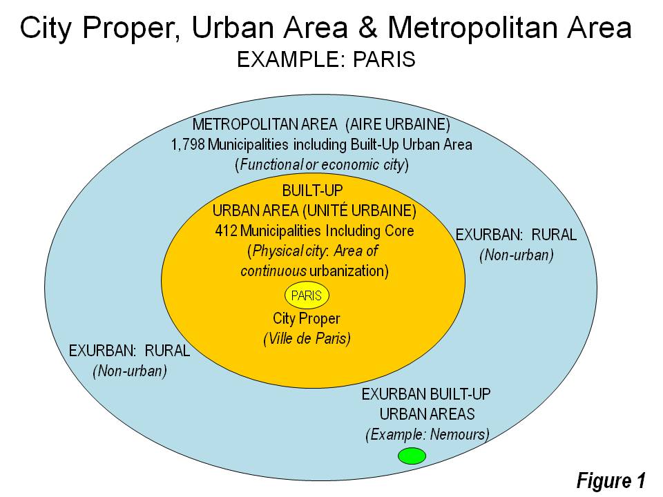
Not surprisingly, these three definitions of the city lead to considerable confusion. Press and internet articles frequently compare apples with oranges and mix cities proper, urban areas, and metropolitan areas. All of these are “cities,” but they are very different.
Genesis of Demographia World Urban Areas
This confusion is a principal reason that we began publishing Demographia World Urban Areas. We were also interested in having data that was not previously available for international cities at the urban area level, such as population, urban land area, and urban population density. Comparisons of urban density were the least reliable, given the limited information.
Three Definitions of the City
There are three basic definitions of the city.
- The City Proper, which is the political jurisdiction of the historical core municipality, such as the Ville de Paris or the City of New York. Most often, these areas are only a small part of a larger urban or metropolitan area, the two generic definitions of a city. There are no neutral demographic standards for establishing such jurisdictions, they are defined neither by physical nor economic standards.
- The Metropolitan Area (called “functional urban area” in Europe) is organized around a core urban area (the physical city), and include the rural areas and smaller urban areas from which people commute to the core urban area.
- The Urban Area, is the physical city, defined by the full extent of contiguous urban development. It is surrounded by rural land (all non-urban land is rural) or bodies of water. Built up urban areas are defined by their city lights visible from a high-flying airplane at night. They are not jurisdictions, such as municipalities, provinces or states, but are defined by where development meets rural areas. Few countries designate urban areas, but the advent of satellite photography and web applications like “Google Earth” make it possible to identify their geographic expanse. In combination with the rapidly improving international census data available on the internet, it is also possible to estimate populations within the urban peripheries.
Highlights: Demographia World Urban Areas
This is the basis for Demographia World Urban Areas, published annually in March or April. It includes ranking tables for the 1,072 identified urban areas with 500,000 or more population, by (1) population, (2) urban land area, and (3) population density.
The Megacities
There is considerable fascination with megacities, which are defined as urban areas with more than 10 million residents. In 1950, there were two megacities: New York and Tokyo-Yokohama. Today, there are 38 megacities.
Tokyo-Yokohama is the largest, with 38.5 million, while New York is ranked 8th with 21.0 million. Jakarta (34.4 million) and Delhi (28.1 million) rank second and third. All of the next four are in Asia:Manila, Seoul, Mumbai and Shanghai. South America’s Sao Paulo and Mexico City round out the top 10.

Zhujiang New Town in Guangzhou-Foshan, the World’s 11th largest urban area.
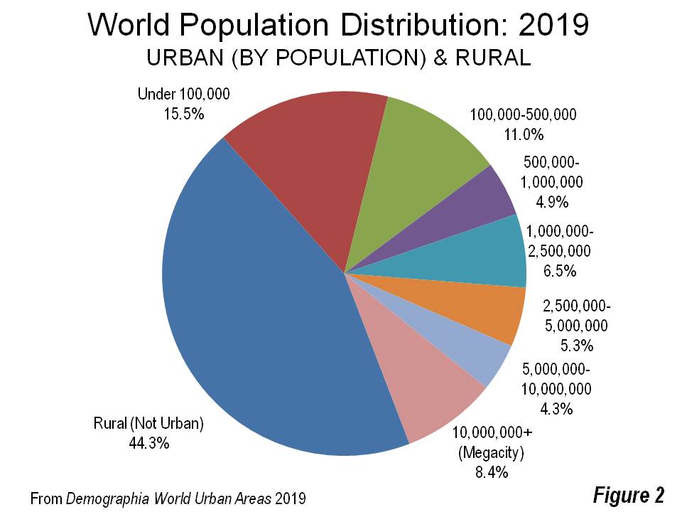
Most Urban Residents Live in Smaller Urban Areas
In recent years, the world’s urban population has exceeded the rural population for the first time. Yet to read some reports, one could get the impression that the typical urban resident lives in one of the largest cities, like Manila, Shanghai, London, or Seoul. In fact, the megacities have only 8.4 percent of the world’s population. Nearly twice that number live in urban areas with fewer than 100,000 residents (Figure 2). In the US, any settlement with a population of 2,500 is considered an urban area.
The median (middle) world resident lives in an urban area about 625,000 residents, about the size of Bakersfield, California or Bremen, Germany.
Urban Densities
Urban densities vary substantially. Dhaka, Bangladesh is by far the densest, at 106,300 residents per square mile (41,000 per square kilometer). This is approximately nine times as dense as Tokyo-Yokohama, 15 times Toronto, 18 times Los Angeles, 20 times New York, and more than 50 times Boston.

Gulshan in Dhaka, world’s densest urban area over 500,000 population.
Urban Land Area (The Urban Footprint)
New York may no longer be the world’s largest urban area in population, but it covers the most land area. Perhaps surprisingly, this is almost twice as large as the Los Angeles urban area, which covers less land than Boston, Tokyo-Yokohama, Atlanta, and Chicago; and is the densest major urban area in the United States.The higher densities of New York’s city proper more than compensate for its lower suburban densities.
Notable Urban Area Publications
For years, the authoritative list has been the United Nations (UN) list of urban agglomerations. Indeed, Demographia World Urban Areas uses the UN definition, which begins: “The term ‘urban agglomeration’ refers to the population contained within the contours of a contiguous territory inhabited at urban density levels without regard to administrative boundaries.”
The UN goes on to indicate, “However, some countries do not produce data according to the concept of urban agglomeration but use instead that of metropolitan area or city proper. If possible, such data are adjusted to conform to the concept urban agglomeration. When sufficient information is not available to permit such an adjustment, data based on the concept of city proper or metropolitan area are used.” Thus, the UN’s list includes urban areas, metropolitan areas, and cities proper.
Perhaps the leading international effort is the Urban Expansion Project, led by Professor Shlomo Angel, which is jointly supported by the NYU Marron Institute and the NYU Stern Urbanization Project. Professor Angel and team also produced the Atlas of Urban Expansion: 2016, which highlighted the pervasive loss of densitythat has occurred in urban areas around the world.
The Changing Urban World
Most urban growth is now in the less developed world. Tokyo-Yokohama, the world’s largest urban area since 1955, could be displaced by fast growing Jakarta and/or Delhi in not much more than a decade. UN projections indicate that less developed regions, which already have 75 percent of the world’s urban population (Figure 3), will account for 95 percent of urban population growth to 2050. This is a substantial change from a half-century ago, when the more developed and less developed worlds had about the same number of urban residents.

Discussion
Leave your comment below, or reply to others.
Please note that this comment section is for thoughtful, on-topic discussions. Admin approval is required for all comments. Your comment may be edited if it contains grammatical errors. Low effort, self-promotional, or impolite comments will be deleted.
6 Comments
Submit a Comment
Read more from MeetingoftheMinds.org
Spotlighting innovations in urban sustainability and connected technology

Middle-Mile Networks: The Middleman of Internet Connectivity
The development of public, open-access middle mile infrastructure can expand internet networks closer to unserved and underserved communities while offering equal opportunity for ISPs to link cost effectively to last mile infrastructure. This strategy would connect more Americans to high-speed internet while also driving down prices by increasing competition among local ISPs.
In addition to potentially helping narrow the digital divide, middle mile infrastructure would also provide backup options for networks if one connection pathway fails, and it would help support regional economic development by connecting businesses.

Wildfire Risk Reduction: Connecting the Dots
One of the most visceral manifestations of the combined problems of urbanization and climate change are the enormous wildfires that engulf areas of the American West. Fire behavior itself is now changing. Over 120 years of well-intentioned fire suppression have created huge reserves of fuel which, when combined with warmer temperatures and drought-dried landscapes, create unstoppable fires that spread with extreme speed, jump fire-breaks, level entire towns, take lives and destroy hundreds of thousands of acres, even in landscapes that are conditioned to employ fire as part of their reproductive cycle.
ARISE-US recently held a very successful symposium, “Wildfire Risk Reduction – Connecting the Dots” for wildfire stakeholders – insurers, US Forest Service, engineers, fire awareness NGOs and others – to discuss the issues and their possible solutions. This article sets out some of the major points to emerge.

Innovating Our Way Out of Crisis
Whether deep freezes in Texas, wildfires in California, hurricanes along the Gulf Coast, or any other calamity, our innovations today will build the reliable, resilient, equitable, and prosperous grid tomorrow. Innovation, in short, combines the dream of what’s possible with the pragmatism of what’s practical. That’s the big-idea, hard-reality approach that helped transform Texas into the world’s energy powerhouse — from oil and gas to zero-emissions wind, sun, and, soon, geothermal.
It’s time to make the production and consumption of energy faster, smarter, cleaner, more resilient, and more efficient. Business leaders, political leaders, the energy sector, and savvy citizens have the power to put investment and practices in place that support a robust energy innovation ecosystem. So, saddle up.


One in four people live in small and mid-size cities (smaller than 500k population). This is eye-opening. I’m going to be a lot more interested in innovation and UrbanTech that targets this market and no longer limit myself to the 10% living in megalopolises. This is a must read.
Agreed Alexander! I’m going to be focusing Meeting of the Minds event sessions and webinars on small and medium-sized cities in the next year a lot more because of this. It’s one of the main reasons we are convening our 2020 Mobility Summit in Stratford, Ontario. Urban sustainability and innovation will be won or lost in small and medium sized cities.
Not clear if the analysis considers Mexico (and Mexico City) to be in North America geographically, or is grouped with South America for some reason.
The sentence “South America’s Sao Paulo and Mexico City round out the top 10.” is confusing in this regard, and so then the pie chart becomes unclear.
Thank you for this. Eye opener in every sense. Took for granted India with one third the area of China and a nearly equal population would be the most dense country especially urban areas.
Dhaka stats mind boggling.
To promote more sustainable urban development, one would think rural areas and major metropolitan cities should consume the segments of towns (under 100k and 100-500k).
Thoughts?
You err in claiming NYC u.a. is larger than L. A. The latter is the world’s largest geographically built up area, but neither the most populated nor densest.