Cascadia Showcases How a Coordinated Corridor Strategy Can Reinforce Urban Innovation

Who will you meet?
Cities are innovating, companies are pivoting, and start-ups are growing. Like you, every urban practitioner has a remarkable story of insight and challenge from the past year.
Meet these peers and discuss the future of cities in the new Meeting of the Minds Executive Cohort Program. Replace boring virtual summits with facilitated, online, small-group discussions where you can make real connections with extraordinary, like-minded people.
A central premise of Meeting of the Minds is that the flexibility, practicality, and focus of municipal governments make them ideal technological and social innovators. But can the ingenuity of U.S. cities be sufficiently amplified to effectively keep up with the pace of climate change, especially in the face of declining federal leadership?
Answering this question requires us to find the most effective scales for replicating urban progress. Metropolitan to regional scale programs can have the greatest impact, while household to district level projects are easiest to implement (Figure 1). Well-functioning cities and their staffs can help society achieve ambitious goals like reversing climate change and relieving global poverty, but that’s not what they are primarily paid to do. Instead, individual cities mostly aim their problem solving at local conditions. Fixing a pothole or increasing bus frequency can bring immediate relief to a neighborhood and kudos to a city council member.
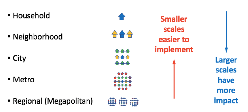
Figure 1. Scales and impacts of urban innovation programs
Organizations like ICLEI and the US Conference of Mayors have long facilitated the sharing of these operational insights. As urban environmental issues have become more prominent, groups like the Urban Sustainability Directors’ Network and Rockefeller Foundation’s 100 Resilient Cities have become more influential. With the advent of smart technology as an urban focus, new groups like MetroLab Network, Global City Teams Challenge, and the World Council on City Data are now emerging.
These networks help all member cities learn from one another. However, there are added benefits that come from comparisons with adjacent centers that share geographic, climatic, political, or cultural characteristics, either within a single metropolitan area or across nearby metros. Just as with scientific experiments, holding most policy variables constant, as is possible when looking at a set of like-minded cities, allows one to better understand the detailed effects of individual factors.
Forging links across neighboring metros requires a higher level of voluntary coordination, because there is rarely any government organization with overarching jurisdiction. In the 1990s and 2000s, regional planners began focusing on “megapolitan” regions, or “Megaregions,” most of which contain two or more metropolitan areas linked by relatively efficient transportation systems. The best known of these is the Boston-New York-Washington “Megalopolis,” but others in the U.S. include the Great Lakes complex centered on Chicago, the “Sun Corridor” between Phoenix and Tucson, and Florida’s I-4 corridor connecting Tampa, Orlando, and Miami. Figure 2 shows the Regional Plan Association’s representation of eleven megapolitans that contained 70% of the U.S. population in less than 20% of the land area in 2008.

Figure 2. One of many possible Megapolitan representations for the U.S. (Regional Plan Association, 2008)
The Cascadia Corridor is a 600 kilometer region that includes three metropolitan areas in the northwest United States and southwest Canada, which share many common traits (Figure 3). Because of the combined technological sophistication and social awareness of municipal, corporate, and academic organizations in Portland, Seattle, and Vancouver; Cascadia is an ideal place to explore the benefits that come from accelerating the exchange of smart innovation on a region-wide basis.
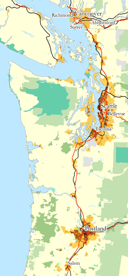
Figure 3. Map of Cascadia showing three main metros (Citynoise, 2006).
Among North American megapolitans, Cascadia is one of the most uniform, and certainly the “greenest.” The region boasts abundant natural resources, nearly carbon-free power generation, four-season recreation, high educational attainment, tech innovativeness, progressive politics, and rich entrepreneurial ecosystems. At the same time, it is challenged by a history of racial intolerance (at least in the U.S. portion), limited venture capital, insufficient affordable housing, and steadily worsening traffic. The Sword of Damocles hanging over the region is the Cascadia subduction zone, where a Magnitude 9 earthquake is overdue; much of the region’s population and their governments remain under-prepared.
Despite all of these parallels, the region’s three metros also have distinct differences, making them an even better laboratory for evaluating the benefits and drawbacks of regional coordination. Portland is the quirkiest, with a strong neighborhood ethos, DIY culture, and longstanding climate change leadership. Its corporate landscape is dominated by two sectors: athletic and outdoor, anchored by Nike, and high-end electronics, built around Intel. Academically, it hosts an accessible, urban-serving university (Portland State); a nationally ranked medical school (Oregon Health and Science University); and specialized outposts of the state’s flagship (University of Oregon) and land-grant (Oregon State) universities.
Seattle is the corporate powerhouse of the three, reflecting the longtime influence of companies like Microsoft, Amazon, and Boeing. It is currently undergoing a massive building boom, typified by Amazon’s expansion in the South Lake Union district, and complemented by major, if long overdue, upgrades to the region’s transportation network. Thanks to Microsoft and Amazon, Seattle is known as the home of cloud computing. The city has very strong cultural and economic ties to Asia. The University of Washington (UW), one of the world’s top research universities, has an outsized influence, although historically it has been focused more outside the region than internally.
Vancouver is the western gateway to Canada, with a breathtaking location, major port, and powerful demographic and financial links to Asia. Overshadowed domestically by Toronto, it lacks the dominant corporate players of Seattle and Portland. However, it hosts large and growing bases for U.S. tech companies including Microsoft, Amazon, and Google, allowing them to tap into global talent pools with fewer immigration hassles. Within the tech sector, Vancouver is becoming known as a hub for augmented and virtual reality. Higher education is dominated by University of British Columbia (UBC) and Simon Fraser University.
In 2016, against this promising backdrop, several large players in Seattle and Vancouver organized the first “Cascadia Innovation Corridor” conference to promote the vision that with proper infrastructure investments and more intentional exchange of people and ideas, the region could become a global leader in green, smart, and healthy economic development. Long-dormant plans for high speed rail were dusted off, coupled with newer notions about autonomous vehicle lanes on I-5, and even a Hyperloop, all aimed at reducing downtown-to-downtown travel times to an hour or less.
At the second Cascadia Corridor Summit, in September 2017, the Canadian Consulate of Seattle launched a regional technology transfer and business incubation consortium, which includes Portland. The State of Washington and Microsoft agreed to fund a new assessment of high speed rail between Seattle and Vancouver. In addition, a new “Nerd Bird” seaplane service was announced to connect South Lake Union with downtown Vancouver.
Recognizing that most of the world’s tech corridors are built around the innovation coming from two or more collaborating research universities, Microsoft has been funding enhanced connectivity between UW and UBC through the Cascadia Urban Analytics Cooperative. The schools are now using this framework to actively expand research links in transportation, housing, public health, genomics, and law, as well as growing parallel training programs in “Data Science for Social Good.”
In 2018 and beyond, several avenues hold promise for demonstrating how Cascadia can become a model for smart, corridor-scale development. The largest benefits can come from deploying the same technologies in three similar yet different settings. For example:

Figure 4. Freight traffic from Mexico to Canada is bottlenecked in Portland and Seattle. Congestion pricing could speed up the whole system while also reducing commuter traffic. Map (Nick Nolte 2006) showing I-5 and BC-99 in red; stars represent Portland, Seattle, and Vancouver.
- The region’s three transit agencies—TransLink, Sound Transit, and TriMet—have each recently introduced travel cards. Sharing of card data and software among the agencies and their academic partners can improve transit access, efficiency, and safety.
- Exchanging crime data across neighboring cities in a single metro has been shown to improve public safety by making it harder for criminals to cross municipal borders to evade capture. Extending this approach throughout Cascadia can amplify these benefits across both state and national boundaries.
- Integration of renewable energy sources across larger Cascadia-wide distribution networks can smooth out demand highs and lows and reduce the need for CO2-intensive “peaker” capacity, as well as providing testbeds for innovative micro-grid solutions that incorporate electric vehicle and home batteries as backups.
- Congestion pricing along the I-5/BC 99 corridor through Portland, Tacoma, Seattle, and Vancouver can help speed freight delivery all the way from Mexico to Canada while also reducing commuter traffic (see Figure 4).
- Public health officials and their academic collaborators in the three cities are developing and testing low-cost, high-resolution monitoring devices to map out and relate sources and sinks of urban air pollution. This integration is increasingly important as climate change makes air pollution from forest fires a regular region-wide summer occurrence.
- Since 2014, member cities in the World Council on City Data (WCCD) have used ISO 37120, the first ISO standard for cities, to measure their progress toward achieving sustainability and operational goals. Portland, Seattle, and Surrey (the second largest city in Metro Vancouver) are all members, and Vancouver is in the process of joining, allowing Cascadia to show how a region can quantify its progress toward operational efficiency, reduced carbon emissions, and more equitable access to economic opportunities.
- The MetroLab Network, set up by the White House in 2015, consists of 40 city-university pairs in the U.S. that are collaboratively pursuing smart city initiatives. Portland/PSU and Seattle/UW were founding members. Adding Vancouver/UBC could create another way for innovative urban ideas to get implemented on both sides of the border.
- The cities of Cascadia, all at risk of a major subduction zone earthquake, could become leaders in urban resilience. Warnings of even a few tens of seconds can save lives. Vancouver, Seattle, and Portland can become testbeds for linking offshore sensors to urban alert systems.
- The Pacific Northwest can also follow Japan’s lead by hardening infrastructure in rail beds, allowing post-disaster recovery teams to tap into protected and preserved underground telecom and power lines.
When our current cities, states, and provinces were established, “digital technology” meant counting on one’s fingers. Political boundaries made more sense than they do today. Now, with near-universal access to all types of data, regions of like-minded people, companies, and governments can form, dissolve, and reassemble for different purposes, just as online communities can shape and redefine personal identities.
A fascinating example is the “define one’s own city boundaries” exercise developed by geographers in the U.S. and U.K (thanks to Garrett Nelson from Dartmouth). Residents of an urban region are asked to draw an outline on an online map of what “their” version of their city includes; the crowd-sourced information is then integrated to show what the collective vision of the region is.
The use of technology to enable the emergence of metro-based regionalism—whether in Cascadia, in London, or in the Pearl River Delta—represents a critical next step in allowing cities to help tackle the most vexing problems facing society today.
Discussion
Leave your comment below, or reply to others.
Please note that this comment section is for thoughtful, on-topic discussions. Admin approval is required for all comments. Your comment may be edited if it contains grammatical errors. Low effort, self-promotional, or impolite comments will be deleted.
Read more from MeetingoftheMinds.org
Spotlighting innovations in urban sustainability and connected technology

Middle-Mile Networks: The Middleman of Internet Connectivity
The development of public, open-access middle mile infrastructure can expand internet networks closer to unserved and underserved communities while offering equal opportunity for ISPs to link cost effectively to last mile infrastructure. This strategy would connect more Americans to high-speed internet while also driving down prices by increasing competition among local ISPs.
In addition to potentially helping narrow the digital divide, middle mile infrastructure would also provide backup options for networks if one connection pathway fails, and it would help support regional economic development by connecting businesses.

Wildfire Risk Reduction: Connecting the Dots
One of the most visceral manifestations of the combined problems of urbanization and climate change are the enormous wildfires that engulf areas of the American West. Fire behavior itself is now changing. Over 120 years of well-intentioned fire suppression have created huge reserves of fuel which, when combined with warmer temperatures and drought-dried landscapes, create unstoppable fires that spread with extreme speed, jump fire-breaks, level entire towns, take lives and destroy hundreds of thousands of acres, even in landscapes that are conditioned to employ fire as part of their reproductive cycle.
ARISE-US recently held a very successful symposium, “Wildfire Risk Reduction – Connecting the Dots” for wildfire stakeholders – insurers, US Forest Service, engineers, fire awareness NGOs and others – to discuss the issues and their possible solutions. This article sets out some of the major points to emerge.

Innovating Our Way Out of Crisis
Whether deep freezes in Texas, wildfires in California, hurricanes along the Gulf Coast, or any other calamity, our innovations today will build the reliable, resilient, equitable, and prosperous grid tomorrow. Innovation, in short, combines the dream of what’s possible with the pragmatism of what’s practical. That’s the big-idea, hard-reality approach that helped transform Texas into the world’s energy powerhouse — from oil and gas to zero-emissions wind, sun, and, soon, geothermal.
It’s time to make the production and consumption of energy faster, smarter, cleaner, more resilient, and more efficient. Business leaders, political leaders, the energy sector, and savvy citizens have the power to put investment and practices in place that support a robust energy innovation ecosystem. So, saddle up.


0 Comments